Sunday, February 5, 2023

Sherman Oaks 1949 Then And Now

A Random Drive Through Sherman Oaks In The 1940s

Let's take a brief ride through Sherman Oaks sometime in 1949. We are going to jump around a bit in the neighborhood, but basically, we are in the vicinity of Greenleaf Street east of the highway.

We'll start our ride on Greenleaf Street heading west just past Cedros Street. Up ahead on the right side of the road, not quite in sight yet, as the road swerves left, is the Sherman Oaks Elementary School.

Greenleaf Street, Sherman Oaks, 1949 randommusings.filminspector.com
Greenleaf Street, heading west, 1949.

The school is still there, but now it is called the Sherman Oaks  Charter School.

Greenleaf Street, Sherman Oaks, 2022 randommusings.filminspector.com
Greenleaf Street, heading west, August 2022 (Google Street View).

We continue down Greenleaf Street, a nice suburban street then and now.

Greenleaf Street, Sherman Oaks, 1949 randommusings.filminspector.com
Greenleaf Street, heading west, 1949.

There is the school fence on our right, behind that driveway. Note the lampost over on the left.

Greenleaf Street, Sherman Oaks, 2022 randommusings.filminspector.com
Greenleaf Street, heading west, August 2022 (Google Street View).

And above is the same spot today, with the fence over there on the right beyond the (greatly widened) driveway across from our friend the eternal lampost.

Greenleaf Street, Sherman Oaks, 1949 randommusings.filminspector.com
Saugus Avenue and Greenleaf Street, Sherman Oaks, Los Angeles, ca. 1949.

Above is the corner of Saugus Avenue and Greenleaf Street in Sherman Oaks, looking west toward the San Diego Freeway ("the 405" to you Californians), in 1949. Is that the same tree there on the corner? Sure looks like the tree has bent the same way, though admittedly it has straightened out some over the decades. 
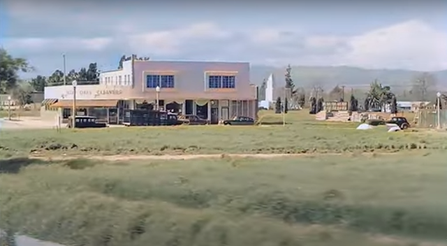
Valley Oaks Cleaners, Sherman Oaks, ca. 1949 randommusings.filminspector.com
Valley Oaks Cleaners off Saugus and Sepulveda, the future site of the current Whole Foods.

The Valley Oaks Cleaners is over to the right, which begat the Westward Ho Market, which begat the current Whole Foods on Sepulveda.
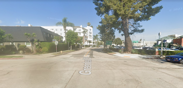
Greenleaf Street at Saugus, Sherman Oaks, 2022 randommusings.filminspector.com
Saugus Avenue and Greenleaf Street in Sherman Oaks in August 2022 (Google Street View).

And above we have the exact location in August 2022. The San Diego Freeway is still there, but it looks a bit different these days. The Whole Foods site is off to the right, mostly out of sight here.

Greenleaf Street, Sherman Oaks, 1949 randommusings.filminspector.com
Greenleaf Street at Kester Avenue, northeast corner, ca. 1949.

Back up on Greenleaf Street, above, we pass a house on the corner of Greenleaf Street at Kester Avenue. Below, is the exact location recently.

Greenleaf Street at Kester Avenue, August 2022 (Google Street View).

Below is the same corner in 1949, but we see the other side of Greenleaf Street in a more straight-ahead shot. Notice the fire hydrant, telephone pole, and other street features on the left.

Greenleaf Street, Sherman Oaks, 1949 randommusings.filminspector.com
Greenleaf Street, looking west, 1949.


Below, is the same view in August 2022.
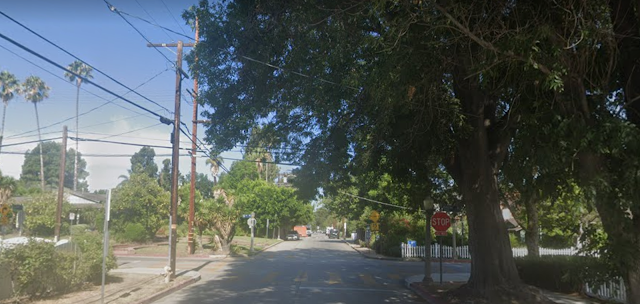
Greenleaf Street, Sherman Oaks, 2022 randommusings.filminspector.com
Greenleaf Street looking west, August 2022 (Google Street View).

Below is Greenleaf Street and Noble Avenue looking west toward the freeway.

Greenleaf Street, Sherman Oaks, 1949 randommusings.filminspector.com
Greenleaf Street at Noble Avenue, looking west.

Below is the corner of Greenleaf and Noble looking in the same direction. Note the similarities in the streetlights and telephone poles - hard to say if some of them are the same, perhaps the streetlamps are. Cars from different eras are parked in the exact same spot - the more things change, the more they stay the same. Also, in 1949 they were not "Stop" signs, they were "Slow" signs - and painted a different color - though they had the same shape and thus would be confusing for a modern driver taken back to that time.
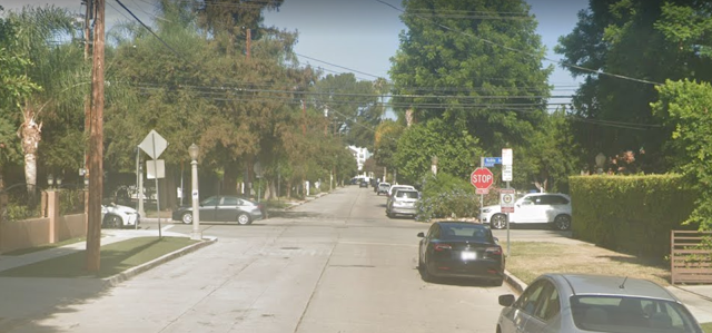
Greenleaf Street, Sherman Oaks, 2022 randommusings.filminspector.com
Greenleaf at Noble looking west, August 2022 (Google Street View).

Below is a 1949 image of Saugus Avenue looking south - for orientation, the San Diego Freeway is out of sight over to the right.

Saugus Avenue, Sherman Oaks, 1949 randommusings.filminspector.com
Saugus Avenue looking south, 1949.

Below is the same street scene from August 2022. As in the other recent shots, the old lamposts - or, if not the same, identical facsimiles - are in the same places.
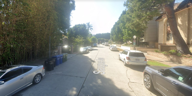
Saugus Avenue, Sherman Oaks, 2022 randommusings.filminspector.com
Saugus Avenue looking South, August 2022 (Google Street View).

You may be wondering, "Is there a point to all this?" Well, no, really there isn't, aside from an educational look at the growth of a neighborhood over time.  It is just, as I said earlier, a nice drive through a suburban neighborhood. Nothing to it at all, aside from my constant refrain in these slices of history - that the more things change, the more they stay the same. Many of the things we take for granted were there long before we were, and will be there long after we have moved along. Enjoy them while it's our time. Thanks for visiting.


2023
Tuesday, December 28, 2021

Then and Now: Burbank, California

Burbank, California, in the late 1940s randommusings.filminspector.com
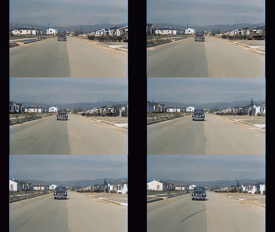
A P-38 Lightning fighter left over from World War II takes off in the distance from the Hollywood Burbank Airport aka Bob Hope Airport (then Lockheed Air Terminal) as we drive down Maple Street. The P-38 fighter was retired from the US Air Force right around the time this film was made, in 1949.

Beautiful Suburban Burbank

One of late-night entertainer Johnny Carson's catchphrases was "somewhere in beautiful downtown Burbank," said in gest to convey the humble location of the studio where he filmed "The Tonight Show." Well, Johnny said that a lot closer in time to the late-1940s film that is the subject of our quick trip back in time than he was to us.

The past always seems a bit odd because it isn't familiar. But it was very familiar to the people seen in this brief drive through 1940s suburbia. Time marches on, Tempus fugit, and I am quite sure that our current gas-burners and McMansions will seem equally quaint to viewers in the year 2100. Here we take some scenes from Burbank ca. 1949 and compare them to the same locations recently.

Below is a beautifully restored version of some old footage that most likely was captured for background shots in motion pictures of the day.


Just for comparison, here is the original footage.

Original footage courtesy of Internet Archive.

To orient you, this is the location of our drive, marked by the red pointer on the map of Los Angeles.

Today's drive is in Los Angeles randommusings.filminspector.com
Location of the drive through Los Angeles (Google Street View).

Today's drive is done once and then repeated. The drive is split up into two parts, and then these two parts are repeated. That may sound confusing, but it's really not when watching the film. We are doing the same drive, which is interrupted once, over again starting about halfway through the film.

We cover mostly the same ground in each section of the drive, though the beginning and endpoints are slightly different.

Map of Los Angeles
Our first drive follows the blue/orange route from the lower right to the upper left (Source: Google Maps).

The first part of our drive is from Pepper Street down Victory Street and thence to Maple Street. It isn't a very long journey, only about half a mile according to Google Maps.

Map of Los Angeles
After the interruption, we turn around and begin from where we left off in the first drive and head south and then west If you combine these two route maps together, that is the drive - which is repeated in the second half of the film (Source: Google Maps).

The second part of the trip begins at our original endpoint at Maple and Pacific. We go down Maple down to Jeffries and stop between Ross and Valley Streets. This portion of the trip is only a bit longer than the first part. All told, in both parts of the drive, we cover barely over a mile. However, we get to see a nice slice of mid-century Americana along the way.

In a roundabout way, we are going from Pepper Street to Jeffries, with a detour up to West Pacific.

The second half of the film is the same trip again. It's not a very exciting film! But it is very interesting if you like seeing the past up close and personal.

Okay, let's compare some scenes.

Burbank in the 1940s randommusings.filminspector.com
Our starting point at Victory Boulevard and Pepper Street in the late 1940s.

The area was still being built up in the 1940s, but you'll really have to hunt down empty lots now.

Burbank recently randommusings.filminspector.com
Victory Boulevard and Pepper Street in February 2021 (Google Street View).

While, obviously, the scene is different in 2021, I look for similarities. It isn't difficult to see some. For instance, the street corner is still rounded. You can see the mountains in the background in the most recent photo if you look closely enough. It's the same intersection, just in different worlds. However, we can add a little bit here to prove it a little better.

I'm going to show that house in the 1940s and you'll see how stepping back a bit gives an even better resemblance. 

Burbank in the 1940s randommusings.filminspector.com
Our starting point at Victory Boulevard and Pepper Street, late 1940s.

Once we see the house, it all comes together. That chimney hasn't changed anything except its exterior coating. The house may have had some work done on it, but it certainly looks like the same structure. Yup, it's the same corner all right.

Let's move on to another comparison.

Burbank in the 1940s randommusings.filminspector.com
Victory Boulevard and Screenland Street, late 1940s.

Okay, here we have a nice house at Victory and Screenland. Notice how the garage is off on the side street, allowing a nice presentable front appearance which was considered very important back in the day. No sidewalk in the 1940s, but you know that's going to change.

Burbank recently randommusings.filminspector.com
Victory Boulevard and Screenland Street, February 2018 (Google Street View).

Checking in recently, we see that the scene hasn't changed much. Same house, same driveway off on the side street (though it appears to have been expanded)... you think they ever painted that house anything other than white? I highly doubt it. I liked the original darker roof though, tbh, made a starker contrast.

On to another view.

Burbank in the 1940s randommusings.filminspector.com
Maple Street at Pacific Avenue, late 1940s.

At the beginning of the second part of our journey, we notice a very distinctive structure on the left in the distance. It certainly dominates the landscape in that 1940s film. Hmmm, I wonder if that survived?

Burbank recently randommusings.filminspector.com
Maple Street at Pacific Avenue, April 2019 (Google Street View).

You betcha! Now that there are so many trees and everything has been landscaped it no longer dominates the landscape quite as much, but that's just context. There it is in the distance at the left-center. In the 1940s, it was simply the entrance to Pierce Brothers Valhalla Memorial Park Cemetery. However, in 1953, only a few years after the film was shot, it was rededicated as The Portal of the Folded Wings Shrine to Aviation. And that is how it is known now and you can visit it if you like.

Burbank in the 1940s randommusings.filminspector.com
Maple Street at Jeffries, late 1940s.

We turn right from Maple at Jeffries Street. In the late 1940s, that was a pretty desolate area, awaiting some houses and love. I bet it doesn't look like that now!

Burbank recently randommusings.filminspector.com
Maple Street at Jeffries, April 2019.

That corner actually doesn't look all that different now. That empty area on the far corner has become the Maple Street Playground, and beyond it is the Luther Burbank Middle School. It was nice to have all that open land to build the school on!

Burbank in the 1940s randommusings.filminspector.com
Maple Street at Victory Boulevard, late 1940s.

Driving south on Maple, we have just crossed Victory Boulevard and notice that large church on the left. That entrance to the cemetery sure looms in the distance, doesn't it? Let's see if the church is still there.

Burbank recently randommusings.filminspector.com
Maple Street at Victory Boulevard, April 2014 (Google Street View).

Well, the church is still there, over there on the far left corner. It is the Victory Celebration Center (they were celebrating a big victory in the 1940s, too). However, at some point, it looks like they downsized from that big white barn-like building to something more tasteful. They certainly widened the boulevard, too. Can't really see the Shrine to Aviation in the distance anymore, too many trees - but it's definitely still there, as we have seen. Just a different look for a different time.

I hope you enjoyed this short drive into the past. As I always say, the more things change, the more they stay the same. Check out some of our other glimpses into the then and now! Thanks for visiting.

2021


Wednesday, December 1, 2021

Then and Now: John's Pizza, Greenwich Village

Warm Memories

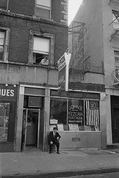
John's Pizza 1976
John's Pizza 1976.

I stumbled across the above photo of John's Pizza taken in 1976 and it intrigued me. For those who aren't familiar with John's Pizza located at 278 Bleecker Street between 6th and 7th, New York City, it is a Greenwich Village institution. Let's do a then-and-now look at John's Pizza on Bleecker Street.

Founded by Naples, Italy, immigrant John Sasso in 1929 (as the canopy loudly proclaims, though it may be even older), John's was an offshoot of Lombardi's Pizza. This is the granddaddy of all pizza joints, a traditional restaurant opened in 1905 on Spring Street down in Little Italy. Lombardi's brought coal-fired ovens to the U.S. world of pizza. They run hot, and anyone who is an aficionado of pizza will tell you that the secret to a good pie is a hot oven. Sasso apparently learned his trade at Lombardi's. That restaurant also began the tradition of classy pizza places not selling by the slice.

John's first location was on Sullivan Street, but in 1934 Sasso moved over to Bleecker Street across from Jones Street.  The Vesce brothers purchased it in 1954, and in 1993, Bob Vittoria, one of their nephews or similarly related, became the majority partner.

Bleecker Street ca. 1950s.

Whether or not the restaurant actually opened in 1929 is a bit hazy. It may have opened to sell "pies" by Filippo Milone at 175 Sullivan Street in 1915, with Sasso taking over due to a marriage ca. 1925. But that's for historians to debate and is irrelevant to the mythology. Until they change the date on the canopy, I'm going with 1929. No matter, we can all agree that John's has been there for a long, long time.

John's Pizza owners 1920s-30s.
John Sasso, Augustine Vesce, Joe Vesce, and Lucille Vesce. This is undated, but probably in the 1950s.

John's is well known for its 800-degree brick oven, its cash-only policy, and the fact that it doesn't take reservations. Unless there's a line outside, you can generally just walk in and grab a spot at one of the tables. If you haven't been there, form a picture of that high school or college joint with unpretentious tables and booths you may have frequented where they served big beers and you could throw darts or do something similar. That's the atmosphere. You know, an unpretentious but fun joint. That's John's Pizza.

However, it's not some corner dollar-a-slice pizza joint. They don't even sell slices. Pizza, calzone, and a few pasta dishes and sides, washed down with wine or beer. You sit down, order beer or the beverage of your choice, and partake of a pie with your friends. That's the deal, and it's a good deal for a Manhattan restaurant because prices are quite reasonable given the location.

Location that eventually became part of John's Pizza.
276 Bleecker, which is now part of Johns’s of Bleecker, February 2, 1937. The neighborhood at one time was full of Italian delis and the like, but now only John's remains. Photo by Bernice Abbott.

"John's Pizza" has become a signature name. It was never as ubiquitous as "Ray's," which as any longtime New Yorker will tell you became practically the obligatory name for corner pizza joints. However, there have been "John's Pizzas" up and down Manhattan at one point or another. But this is the original one (and no, not the "original" as in "Original Ray's Pizzas," but the real deal).

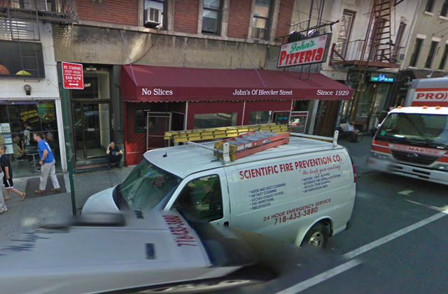
John's Pizza 2009.
John's in May 2009 (Google Street View).

John's also differs from many other pizza joints in not staying open late into the night. Closing time traditionally has been 10:00 p.m. Monday - Thursday and 11:00 otherwise, be there by then or come back some other day. If you waltz in right at closing time, you'll have to take your pie to go. It's a classy joint, appearances can be deceiving.

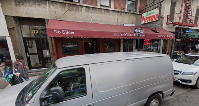
John's Pizza 2009.
John's in June 2019. While the restaurant hasn't changed much in the ten years since the previous photo, the vans outside have gotten sleeker. (Google Street View).

John's has some practical advantages from being around so long. It is grandfathered in to use coal-fired ovens, which otherwise are not permitted. That's a nice barrier to entry for any business, not that John's needs any help. It also has become a selling point for the restaurant online. The pies have a  distinctive look as a result. The crust can be toasted black and crisp, and they slop on a lot of olive oil. Yes, it's quite tasty. New York City's clean and clear tap water from upstate no doubt helps the quality.

Among other authentic touches, the walls have photos of celebrities who have stopped by over the years. The worn wooden booths have etchings from patrons of long ago. The place has real atmosphere.

I had some great meals at those tables in my otherwise misspent youth. Great place to take a date who is down-to-earth. Or old schoolmates. Or visiting out-of-town relatives. Everyone should be able to afford the meal without taking out a second mortgage and be nice and full when they walk out. I can't say that about other well-known NYC restaurants.

John's Pizza 2019
June 2019 (Google Street View).

John's had to shut down its indoor dining in 2020 due to the pandemic. However, it reopened for indoor dining at 25% capacity on 12 February 2021. It also has or had outdoor dining. You can't deprive New Yorkers of their classic pizza!

2021


Tuesday, November 9, 2021

Then and Now: Fordham Road at Valentine Avenue

History in a Bronx Intersection

Fordham Road in the 1950s randommusings.filminspector.com
Fordham Road at Valentine Avenue, looking east, 1951 (The Bronx County Historical Society Research Library).

It's easy for me to get caught up in Manhattan, New York, because there's so much to see there. However, I do venture out into the "outer boroughs" now and then, and this is one of those times. Let's do a then-and-now of Fordham Road at Valentine Avenue in the Bronx, NYC

The first thing I want to point out to people unfamiliar with New York City customs is that the avenues are sometimes streets and the roads are sometimes avenues. I know this makes no sense, but the main drag here is Fordham Road and the sidestreet is Valentine Avenue. This isn't Paris and the Avenue des Champs-Élysées, but it is a major hub near the Grand Concourse. As Jack would say, that ain't beanbag!

Another thing is that the area had a real small-town feel back in the day. You can spot Whelan's Drug Store, Gorman's fast food joint, Bond's clothier, and the like. If you took that 1951 street scene and transposed it to the midwest of the era, it would not look out of place at all. Believe it or not, there are still scattered sections of the Bronx that have a somewhat similar quaint feel, but it is long gone from Fordham Road at Valentine Avenue.

Fordham Road at Valentine Street 1960s.
Fordham Road at Valentine Avenue, looking east, 1960s.

Above, we're looking northeast. In the 1951 shot, you can just see the edge of that billboard on the extreme left.

There are quite a few shots available of Fordham Road at Valentine Avenue. It has quite a history, with its shares of ups and downs, and we'll see some of them play out in these scenes. The top photo on this page from 1951 was taken on Fordham Road looking east toward Fordham University. You can see Keating Hall of the university in the 1951 photo and more recent ones because it was built in 1936 and is something of a landmark in the Bronx.

Fordham Road at Valentine Street.
Fordham Road at Valentine Avenue, looking east, October 2019. You can see Keating Hall at Fordham University, which was built in 1936, in the center of this recent photograph just as in the 1951 one (Google Street view).

Above, the same view looking east as in the 1951 photo. The billboards are all gone, Woolworth's is gone (bankrupt in the 1990s), and now it all has that dreary suburban strip-mall feel.

I'm going to show all parts of this intersection. While it may get a bit confusing which way we're looking, fortunately, there are certain landmarks such as Keating Hall to help us out. 

We've been looking east. Let's turn around and look the other way, toward the west.

Fordham Road at Valentine 1926.
Fordham Road at Valentine Avenue, looking northwest, 1926.

Turning around from virtually the same spot as the original 1951 photo was taken and looking toward the northwest, we see on the right (north) side of the street what later became the grand RKO Fordham Theater in 1926. Designed by William H. McElfatrick and opened on 14 April 1921 as Keith's Fordham Theater, it featured vaudeville acts. With vaudeville on the ropes and the talkies luring moviegoers into the theaters, RKO bought it in 1929 and renamed it RKO Fordham. It became one of seven RKO theaters in the Bronx.

Fordham Road at Valentine Avenue, looking northwest, 1940s.

Looking a little further west, we see how the area looked in the 1940s, with streetcars.

The RKO Fordham didn't show exclusive films - that was the job of the Paradise - but certainly was successful.

RKO Fordham, ca. 1960.

Troy Donahue and Connie Stevens on the stage together at the RKO Fordham! Bestill my heart! I don't think they ever starred in a film together, so I'm not sure why they were there. However, I think we can call this the halcyon days of the areas.

A quick look at the southeast corner (I think) of Fordham Road and Valentine Avenue. Looks like the 1950s to me. Imagine being a time traveler set down in some random year in this area, it would be awfully difficult to guess the exact year!

In 1974, the RKO Theater was still there, looking a bit worn and tired. It was, after all, over 50 years old by this point and we all show our age over the decades. There are some interesting similarities to how this area looked in 1974 and how it looks recently, however.

Fordham Road at Valentine Avenue, looking northwest, October 2019.

First, I was able to precisely locate the recent shot directly above to the 1974 scene because a few things haven't changed. Namely, that building in the distance with the billboard is still there (though the billboard has shifted position). The red firebox in the 1974 shot just visible on the left is still there, kind of, though in a vastly different form (no doubt slimmed down to improve intersection visibility). The stoplight looks the same, though it looks as though they shortened the pole and removed the street signs to the opposite corner for some reason.

But, overall, a person transported from 1974 to 2019 should be able to recognize that they're in the same place at Fordham Road and Valentine Avenue even though the distinctive RKO Fordham is gone.

And that brings us, as Paul Harvey would say, to the rest of the story.

The Fordham Theatre lasted through the 1970s and was triplexed in 1976. It added a fourth screen in 1980 as cinemas became multiplexes in a bid to survive against television. However, as the recent photos illustrate all too vividly, the area was in decline.

The neighborhood’s business district lost its small-town feel, the nondescriptive chains moved in, and that was that. The Fordham Theatre closed and was demolished in March, 1987. It was replaced by strip-mall style retail buildings populated by the usual banks and pharmacies and random outlets. 

Sic transit gloria, as they say, at least the old neighborhood had some style and character even if it wasn't perfect.

I hope you enjoyed this random walk down Fordham Road at Valentine Avenue. The more things change, the more they stay the same, and this intersection does illustrate that in its own way. People shop differently now and are entertained differently, and you can see those changes through the camera lenses.

Thanks for stopping by, and please visit some of my other pages in the Then and Now series!


2021

Tuesday, October 5, 2021

Then and Now: F.A.O. Schwartz at 58th and 5th

Times Haven't Changed That Much On Fifth Avenue

58th and 5th 1984 randommusings.filminspector.com
58th and 5th Avenue in NYC, 1984.

I like city views that show how little time can mean to big cities. If you go to many places in Paris or London, they'll be exactly like they were in the 1800s. New York City has some of those spots, too, though they're a bit less common. But sometimes you come across a view that has changed very little in almost 40 years, and that's saying something.

Above we have a view of 58th and 5th Avenue in 1984. If you're a native New Yorker or a longtime resident, you'll recognize the scene instantly even though it isn't taken from a typical tourist vantage point. We're looking south toward the Empire State Building, which you can see pretty clearly in this shot silhouetted against the sky. Just for fun, let's do a comparison with how this scene looked recently.

58th and 5th June 2019 randommusings.filminspector.com
58th and 5th, looking south, in June 2019 (Google Street View).

While I couldn't get the same precise angle, the above is close enough. It shows a similar view south toward the Empire State Building. Let's pick out the things that are the same and a very few that have changed.

Southeast corner of 58th and 5th, July 2021 randommusings.filminspector.com
58th and 5th, looking east, in June 2019 (Google Street View).

The first thing you will have noticed if you have very sharp eyes is that the business at the extreme left of the 1984 photo (on the southeast corner of 58th Street) was F.A.O. Schwartz. It was an institution in 1984 and it likely seemed it would never close its flagship store on 5th Avenue. You may remember it from "Big" (1988) when Tom Hanks danced on the giant piano. New Yorkers fondly remember it for its annual Christmas displays, one of the highlights of the season.

F.A.O. Schwartz operated at 745 Fifth Avenue, the site shown in the 1984 picture and the one directly above, until 1986. Then, after some mergers and acquisitions that were all the rage in 1986, a new owner moved it across 58th Street to 767 Fifth Avenue, better known as the GM Building. That would be behind and to the left of where the 1984 photographer was standing.

Alas, after numerous ownership changes and a bankruptcy, F.A.O. Schwartz wound up being bought by Toys 'R Us in 2090. That corporation had a lot of problems. So, the flagship store in the GM Building closed down in 2015.

But not to fear! F.A.O. Schwartz reopened its store at 30 Rockefeller Plaza in November 2018. So, we can all still get our holiday fix there.
The GM Building at 767 Fifth Avenue NYC randommusings.filminspector.com
The GM Building at 767 Fifth Avenue on the left, with 745 Fifth Avenue at the center-right in August 2021 (Google Street View).

Just to give a little perspective, the above capture shows the two sites of F.A.O. Schwartz on Fifth Avenue. The old site from 1931-1986 is in the center-right, while the 1986-2015 location in the GM Buildings is at the left. Yes, they literally just moved across the street. I personally identify F.A.O. Schwartz as being in the GM Building on the ground floor. It was spacious and had good light. I saw Susan Sarandon, who lives nearby, give some kind of presentation there in 2001. It really was a great location.
Bergdorf Goodman, 58th and 5th Avenue NYC randommusings.filminspector.com
58th Street and 5th Avenue, looking southwest, June 2019.

Speaking of Bergdorf Goodman, you probably knew that it was that massive building on the far side of 5th Avenue in the 1984 photo. It has been there since 1928, so its centenary is coming up fast. Now, while it may have seemed like F.A.O. Schwartz was eternal, Bergdorf Goodman on 5th Avenue actually is eternal. It seems that if there's ever, God forbid, a nuclear holocaust, the cockroaches will still go to Bergdorf Goodman to buy their $300 sweaters. Bergdorf opened a men's store across the street (on the east side of 5th Avenue) in 1990 and since has expanded to take over the F.A.O. Schwartz space. 

You may remember Bergdorf Goodman from the film "Arthur" (1981). It was already a long-established presence then. However, Neiman Marcus, which owns Bergdorf Goodman, recently filed for bankruptcy due to the 2020 pandemic, so who knows what the future holds in store for it. Strangely enough, due to numerous corporate transactions, F.A.O. Schwartz, which has recently opened stores in Beijing, London, And Dublin, now is probably more financially sound than Bergdorf Goodman. That's life in the big city.
Liza Minnelli, Dudley Moore, and Sir John Gielgud in "Arthur" (1981) randommusings.filminspector.com
Bergdorf Goodman, 754 Fifth Avenue, in the background of a scene from "Arthur" (1981).

Anyway, so the view of Fifth Avenue south from 58th Street hasn't changed much since 1984 aside from some that. If you go there today, you'll see basically the same view and probably will for decades to come. As I like to say in this series, the more things change, the more they stay the same, and the view south from 58th Street down Fifth Avenue in NYC proves it.

Thanks for stopping by! Please visit some of my other pages as we look at how things looked then, and now.

2021