96th Street and Second Avenue, Manhattan
 |
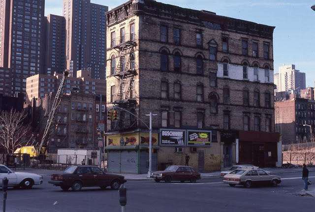
| Second Avenue at 96th Street, southwest corner, New York, in 1985. |
One of the biggest changes in New York City over the past few decades has been the changing character of certain neighborhoods. The area of Manhattan is on the fringes of the neighborhood known as Yorkville, with its southern boundary at East 79th Street and its northern at East 96th Street. This is a good example of a neighborhood that has seen a lot of development during that time. The above photograph from 1985 was a bit difficult to place at first because the area has changed so much, but I finally pinpointed the location. So, here we will do a comparison of East 96th Street at Second Avenue from 1971/1985 to 2018.
This post is also an example of how confusing it can be to identify a site from an old photo! But I think we have it correct now.
Above is the same corner - the southwest corner of 96th Street and Second Avenue - taken 14 years earlier, in April 1971. This was part of a series of photographs taken of Second Avenue in preparation for construction of the Second Avenue Subway (yes, the same one that only opened fairly recently, that is how long things can take in New York City - but if you think that's bad, look into the history of the subway in Rome, Italy!).
We can see that same five-story building on the southwest corner of 96th Street. It looked just as derelict in 1971 as it later did in 1985! Same fish (I think) artwork on the store along Second Avenue! Looks like they at least changed out those billboards on 96th Street between 1971 and 1985, though. If you have some kind of misconception that Manhattan is a place where things change constantly - comparing those two photos should set you straight! That corner was just in a time drift for decades. But then, the 1970s were hard for Manhattan.
Incidentally, that building in the distance on the west side of Second Avenue with the prominent water tower in the 1971 photo - I believe that is the Newbury, 250 East 87th Street, New York, NY, 10128. It was completed in 1970, so would have been brand new in the 1971 Transit photo. You can't see it in the 1985 due to perspective - but it was there, as it remains there in 2023.
Now, let's update things.
 |
| Southwest corner of 96th at Second Avenue in June 2022 (Google Street View). |
Above is the same corner as in the 1985 photo. Normandie Court Apartments III was built in 1986 during a frenzy of construction throughout Manhattan due to some tax credits. The current building extends from 225 East 95th Street, to East 96th Street. In the 1985 photo, you can see where they were clearing the construction zone for the Normandie Court building, apparently they just had not yet gotten to the final building on the corner when the photo was taken. Perhaps the owner was a holdout - being the last building left on the site of a major construction project could mean major dollars, with the condition of the soon-to-be-torn-down building itself being irrelevant. The 1985 photo may have been what is called a "demolition photo," made just before a structure is torn down by the construction company. There's probably an interesting background story there we'll never know.
I think we can all agree that the neighborhood looks a lot more updated now!
For orientation, the tall building you can see to the left in the background of both photos is (I believe) Ruppert House, 222 East 93rd Street, New York, NY (trying to line up the same angle is tricky, but I think that is the one). The building to the left (looking south) of 222, namely 245 East 93rd or Astor Terrace, was not built until 1986 (yes, that year comes up over and over in Manhattan real estate), so it obviously could not have been in the 1985 photo.
The 42-story Ruppert House Yorkville apartment building with 650 residential units was built in 1973, so was already a veteran in the 1985 photo, though it was renovated in 2004 and thus may not look exactly as it did (looks pretty similar to me, though). You can see how, back in the 1970s and 1980s, that building on 93rd Street was on "the fringes" of the Upper East Side, and more so the new Normandie Court building on 96th Street - now, not so much, the whole areas has been gentrified.
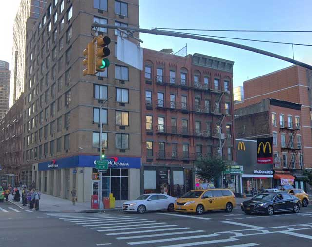
Below, for comparison, is the opposite - northwest - corner of the same intersection recently, just to show how the neighborhood has changed. I originally thought that was the same view as in the top 1985 photo, but as a helpful commenter noted, I was mistaken and looking the wrong way. But now, having done a bit more research myself, it all makes sense and everything lines up. I actually remember being a bit confused about how things lined up originally because there were some incongruities, but now we have it right, I believe.
 |
| Google Street View of East 96th Street and Second Avenue, northwest corner, NYC (Google Street View). |
In the original photo, we are looking at the southwest corner of Second Avenue at 96th Street. The building shown is on the fringes of East Harlem since it is on the dividing line of 96th Street. That may mean a great deal to real estate agents, but living right on the fringe of another neighborhood, with views of that area, these days really makes it a minimal distinction to make these days as everything is gentrified (it may have meant something entirely different, say, in 1950). It also is fair to say that the area looks a lot cleaner and ship-shape now, less grungy and more orderly. That is what gentrification will do for you.
To give a little more context, below is the same intersection (I think we are looking north) on March 26, 1941. The city is disassembling the elevated subway, which went out of service on June 11, 1940. I believe that lamp post on the extreme left is in the same location as the one in the recent picture, though obviously it has been swapped out (for the worse, IMHO).
 |
| Second Avenue at 96th Street, March 26, 1941 (courtesy Norvin H. Green collection, New York Historical Society). |
All this just shows you how important a few blocks could mean in Manhattan, given the massive changes just south of there. This is a pretty good illustration of the slow march north of what we consider the Upper East Side, which now pretty much just continues with much the same character up to Harlem.
 |
| Looking south toward the same location at the corner of 96th Street and Second Avenue, NYC (Google Street View). |
Anyway, I hope you enjoyed this entry in my "the more things change, the more they stay the same" series. Please visit some of my other pages where I examine the evolution of cities over time.
2023

Hi James, great post, and I myself love the history of NYC, and since 2003, when I moved to the Carnegie Hill part of East 96th Street, between 5th and Madison, I've been learning and researching continually to build my expertise as just one of a likely community of informal historians of the neighborhood and beyond. Regarding your 1985 photo at the top of your post, it is *not* the same corner as in the next Google View photo; 1985 shows the *southwest* corner as opposed to the northwest corner. It was actually quite easy to place the photo (at least for me), because talking to old timers who remember the Blimpie sandwich shop storefront and other older photos (one from 1970 and another from 1940s.nyc) corroborate that this was the SW corner of 96th and 2nd. Another clue is the traffic: two-way traffic on 96th St in the 1985 photo and one-way southbound traffic on 2nd Ave in the Google photo. That having been said, the building in the 1985 photo was eventually torn down and about 75% of the block bounded by 95th and 96th, and 2nd and 3rd, was redeveloped into the Normandie Court apartment complex, completed in 1987. And with the opening of the 2nd Ave Subway in 2017, where that lone building was in 1985 is now one of the entrances to the new subway line.Your 4th photo in your post gives an idea of what stands today in place of 1985, the leftmost building and in the background is one of the tall apartment buildings of Normandie Court, stretching from 96th down to 95th St.
ReplyDeleteThank you for the correction - you are absolutely right. I found a 1971 photo showing that it was exactly as you said. The similarities between the buildings on the southwest and northwest corners - perhaps, who knows, built by the same company at the same time - completely misled me. But in my defense I did have an inkling when I posted originally that something was off. Now I think we have it right. Thank you for your attention to detail!
Delete